Mount Timpanogos is 11,752 feet of Wasatch limestone that locals treat like a rite of passage. Ask anyone in Utah Valley if they hike and the first question back is always the same: “Have you done Timp?” It’s the second tallest peak in the Wasatch Range, behind only Mount Nebo to the south, and it’s one of only eight ultra-prominent peaks in Utah with more than 5,000 feet of topographic prominence.
I’ve done Timp twice. Once solo via the Timpooneke Trail in September 2014, and once with a partner via Aspen Grove in July 2017. Timpooneke is 14 miles round trip with 4,300 feet of gain. Aspen Grove is 13.8 miles with 4,800 feet. Both routes meet at the saddle below the summit and share the final 0.75-mile ridge walk. But they’re different hikes with different personalities, and which one you choose depends on what kind of day you want.
Two Trails, Honest Comparison
The Timpooneke Trail and the Aspen Grove Trail are the two standard routes up Mount Timpanogos. They’re close on paper (Timpooneke: 14 miles, 4,300 feet of gain; Aspen Grove: 13.8 miles, 4,800 feet) but the experience is different enough that it’s worth understanding both before you pick one.
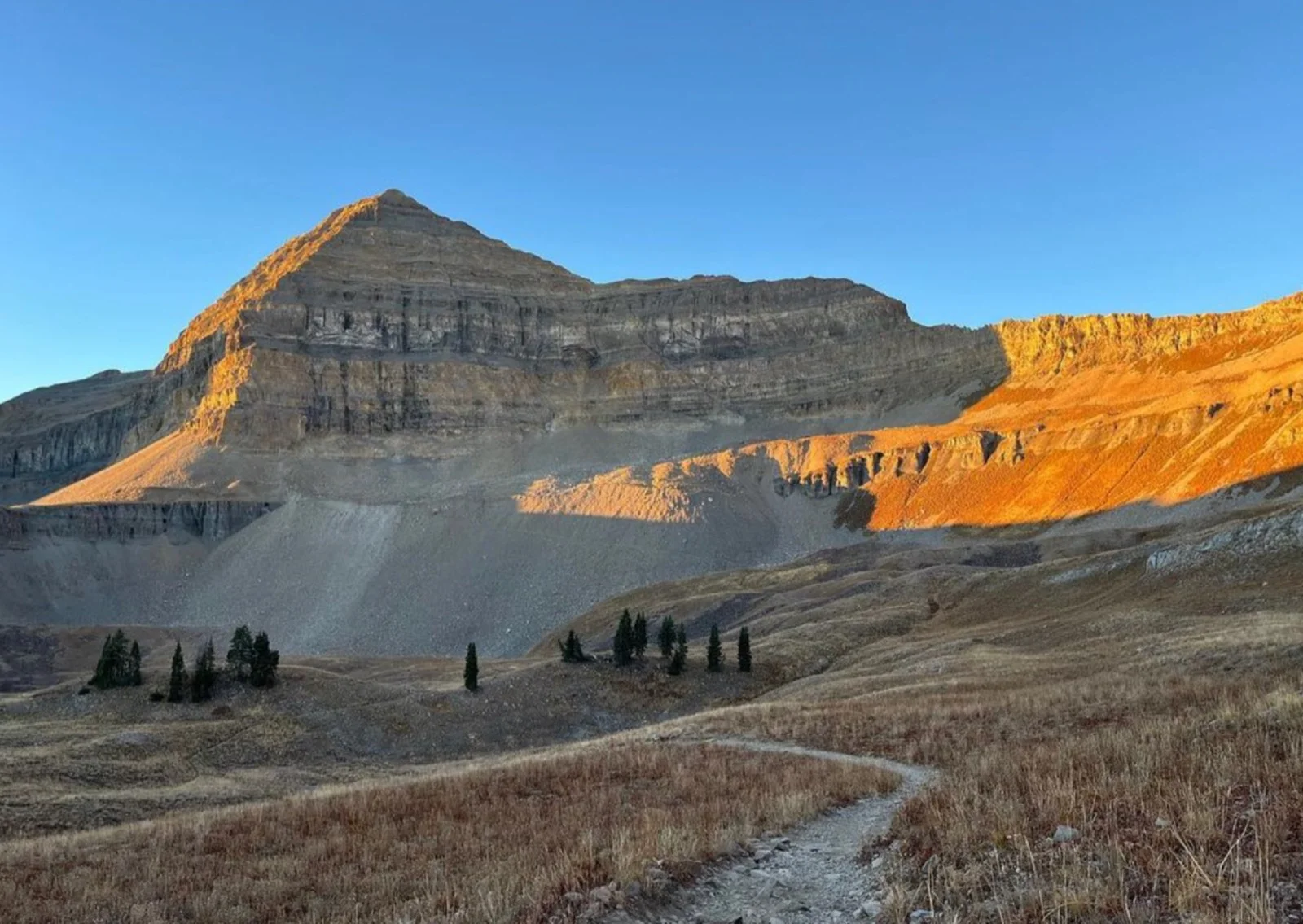
Timpooneke Trail starts from American Fork Canyon on the north side. The approach is gradual through forest, passes Scout Falls at 1.4 miles (good water stop), then climbs steadily through the South Fork drainage. The upper basin is the highlight. It’s a wide, open alpine meadow with Timpanogos towering above it. In wildflower season, this is where you get the famous Timpanogos photo. The trail gains about 2,400 vertical feet over 3.4 miles from Scout Falls to the upper basin, then another 600 or so to the saddle.
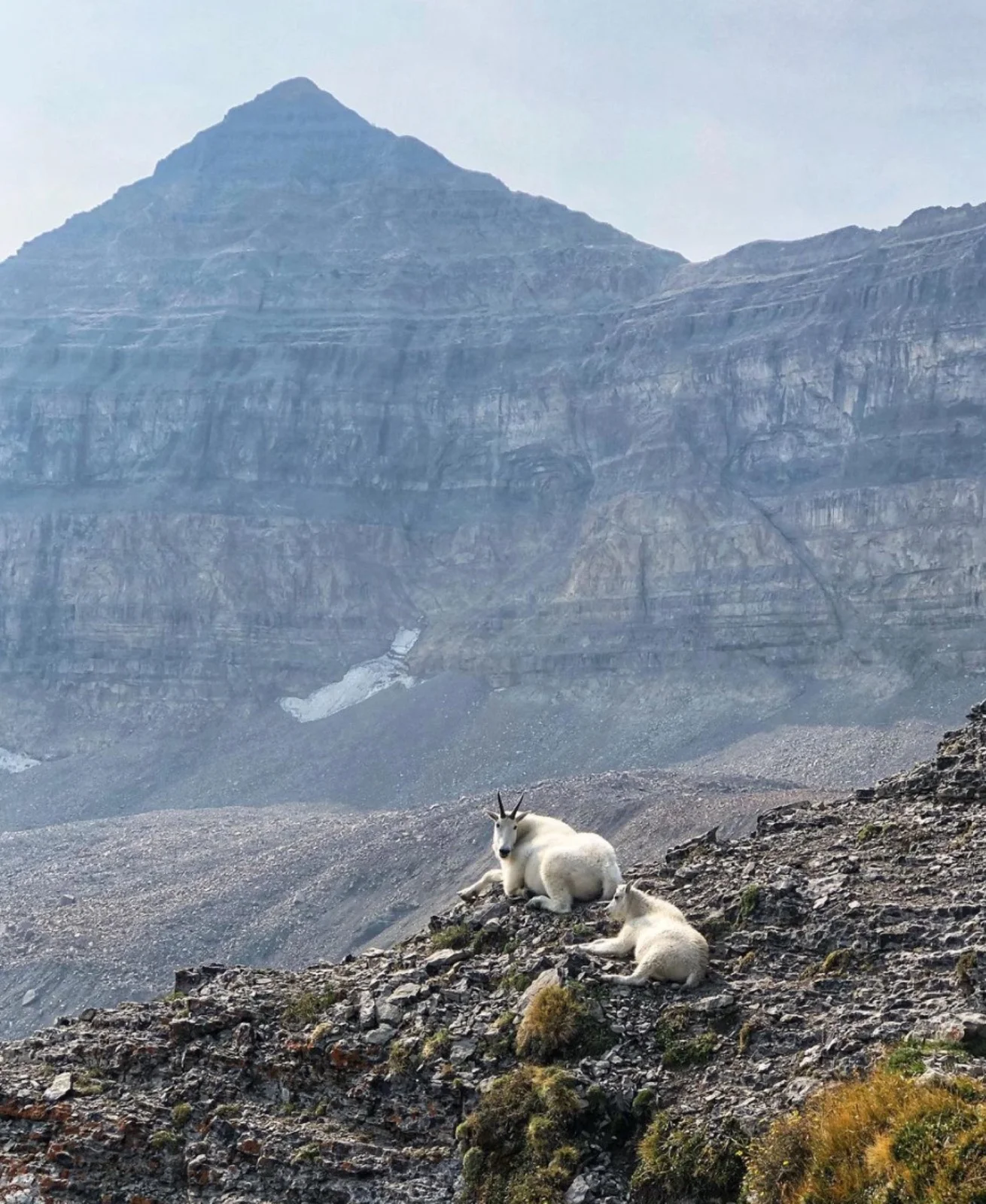
Aspen Grove Trail starts from the south side off the Alpine Loop Road, about 2.5 miles past Sundance. It’s a more eventful route. You’re out of the trees almost immediately and gaining elevation fast: roughly 1,200 feet in the first 1.5 miles. You pass Timpanogos Falls early, then cross the Primrose Cirque (more on the snow situation there in a minute), and eventually reach Emerald Lake at around the 4-mile mark. The lake is stunning. Crystal clear, fed by the Timpanogos glacier above it, and surrounded by mountain goats that have zero interest in giving you personal space. Expect mountain goats on Timpanogos. Not maybe. Every hike, every route, every season.
My take: I prefer Aspen Grove. The waterfalls early on, Emerald Lake as a midpoint destination, and the variety of terrain make it a more interesting hike mile for mile. Timpooneke is the better choice if you’re going in wildflower season (mid-July through early August) because that upper basin meadow is genuinely spectacular. If I had to pick one trail for a first-timer doing Timp in late summer or fall, I’d send them up Aspen Grove.
The Solo Hike: Timpooneke, September 2014
I started from the Timpooneke Trailhead at first light on a Wednesday in September. Midweek in September is a different mountain than a Saturday in July. The parking lot was maybe a third full. By contrast, expect both parking lots to be completely full by 7 AM on summer weekends. That’s not an exaggeration. If you’re planning a weekend hike in July or August, you need to be parked by 6:30 AM or you’re walking extra road miles.
The first stretch through forest to Scout Falls is pleasant and unremarkable. Scout Falls at 1.4 miles is worth a brief stop. It’s a reliable water source and a natural break point before the trail starts climbing in earnest.
From Scout Falls, the Timpooneke Trail follows the South Fork drainage upward. The gradient is steady but not punishing. You gain about 2,400 feet over the next 3.4 miles to the upper basin. In September, the wildflowers were gone but the meadow was still striking. The scale of the upper basin is hard to convey. Timpanogos fills the entire southern horizon and the flat expanse in front of it makes the mountain look even more imposing than it does from the valley floor.
The upper basin has multiple trail options. Stay right toward the saddle. Going left connects to the Aspen Grove Trail and Emerald Lake, which is a fine side trip if you have the legs for extra miles. In snow conditions, the upper basin becomes choose-your-own-adventure. Just aim for the obvious saddle between the main summit and the north ridge. You’ll find your way.
The saddle itself is a legitimate viewpoint. Utah Valley drops away more than a vertical mile below you. To the right, a faint ridge trail heads toward North Timpanogos. If you want guaranteed solitude on an otherwise crowded mountain, that’s where you find it.
Saddle to Summit
From the saddle, the summit is 0.75 miles along the ridge to the left. The terrain looks more exposed and intimidating than it actually is. There are some loose rocks to navigate and the drop-off into Utah County creates a sense of exposure, but the trail is Class 1 the entire way. No scrambling required.
The summit has a small metal hut that’s become a landmark and an informal summit register. It’s been there long enough that most hikers consider it part of the furniture.
The views from 11,752 feet are comprehensive. Mount Nebo is visible to the south, the only Wasatch peak taller than Timp. Cascade Mountain, Provo Peak, and Spanish Fork Peak are all identifiable. Utah Lake spreads across the valley floor to the west. To the north, Box Elder Peak is the obvious triangular summit. The Salt Lake Valley is visible beyond it, though Salt Lake City itself hides behind Lone Peak. On a clear day, Kings Peak in the Uintas is visible to the east.
The Partner Hike: Aspen Grove, July 2017
Coming back via Aspen Grove in July was a completely different experience. The trail is more aggressive from the start. That 1,200-foot gain in the first 1.5 miles wakes your legs up immediately. Timpanogos Falls was running strong in mid-July and worth the quick detour.
The Primrose Cirque is the section that changes the most between seasons. In September 2014 on the other side of the mountain, snow wasn’t a factor anywhere. In July 2017 on the Aspen Grove side, the Primrose Cirque still had significant snow coverage. The cirque is infamous for holding snow into late July and sometimes into August in heavy snow years. Trekking poles were sufficient for our crossing, but I’ve heard from hikers who needed microspikes during the first week of July in big snow years. It’s worth checking recent photos online before you go. Timp is popular enough that someone has posted trail conditions within the last few days at any point during the summer.
The Primrose Cirque crossing is about a mile long with 1,000 feet of elevation gain. At the top, you’re roughly 3 miles and 2,300 vertical feet into the hike. From there, switchbacks lead up a valley before things level off as you approach Emerald Lake.
Emerald Lake is the best midpoint destination on any Wasatch hike I’ve done. The water is a vivid emerald green, fed by glacial melt from above. It’s the most popular overnight camping spot on the mountain, and for good reason. Water is abundant, the setting is dramatic, and the goats provide entertainment whether you want it or not. Filter your water here. The mountain goat population is healthy and they are everywhere near the lake.
From Emerald Lake, if you have energy for a side objective, nearby Roberts Horn is a straightforward scramble. At the summit you’ll find a large Buddha statue that someone carried up there. I still don’t understand who did this or why, but it’s one of the more bizarre summit finds I’ve encountered.
Why Timpanogos Endures
Timpanogos isn’t the tallest peak in the Wasatch. It just looks like it. The mountain has a massive rockface that dominates the skyline from every direction. From the valley floor in Orem and Provo, it fills the eastern horizon. From I-15, it’s the peak your eyes go to first. But the view that really sells it is from the east side, driving through Heber toward Provo. The headwall from that angle is enormous. It dwarfs everything around it in a way that the elevation numbers don’t capture. Nebo is technically taller. Timp looks bigger.
That visual presence is part of why the mountain became Utah’s rite of passage. In the greater Salt Lake City area, when you tell someone you like to hike, the first question is almost always the same: “Have you hiked Timp?” It’s how people figure out if you’re someone who says they hike or someone who actually does. And the number of people who can say yes is surprising. Timp isn’t some obscure peakbagging objective. It’s the hike that Scout troops, college roommates, and families with teenagers all end up doing. The trailhead parking lots on a July Saturday tell you everything you need to know about how deeply this mountain is woven into the culture here.
What makes Timp earn that status is that it puts the best of the Wasatch into a single long day. Waterfalls, alpine meadows, a glacial lake, mountain goats, exposed ridgeline, summit views that stretch from the Uintas to Utah Lake. Most Wasatch hikes give you one or two of those. Timp gives you all of them across 14 miles and nearly 5,000 feet of gain. It’s a serious day. It’s also a complete one. You come down having seen everything the range has to offer, compressed into a single route.
I think that’s why the question persists. “Have you done Timp?” isn’t really about the summit. It’s about whether you’ve put in a full day in these mountains and come back understanding what the Wasatch actually is.
Logistics and Planning
Trailhead access: Timpooneke is reached via American Fork Canyon. After entering the canyon on the Alpine Scenic Highway, pass the Timpanogos Cave National Monument, take the right fork 2.5 miles later (left goes to Tibble Fork Reservoir), and continue 3 miles to the trailhead past the Timpooneke Campground. Aspen Grove is on the Alpine Loop Road, 2.5 miles past Sundance. Both trailheads have vault toilets and roughly 100 parking spaces.
Parking: Both lots fill by 7 AM on summer weekends. Midweek is dramatically less crowded. An early start matters for parking and for avoiding afternoon heat above treeline.
Time: Plan for 10 to 12 hours including stops and summit time. Fit hikers moving efficiently can do it faster, but nearly 14 miles and 4,300 to 4,800 feet of gain is a full day regardless of your pace.
Water: Scout Falls (Timpooneke) and Emerald Lake (Aspen Grove) are reliable water sources. The upper basin generally has water available during summer. Filter everything. Mountain goats are abundant near every water source on this mountain.
Season: July through September. Early July may have significant snow on the Primrose Cirque (Aspen Grove) and in the upper basin (both routes). By early August, snow is almost always gone. September is drier, less crowded, and cooler, but wildflowers are finished.
Permits: None required. No reservation, no lottery, no day-use fee. Just show up and hike.
Car shuttle option: You can hike up one trail and down the other if you set up a car shuttle or have someone willing to drop you off and pick you up on the other side. This is the best way to see both routes in a single day, but it requires logistics.
The South Timpanogos Extension
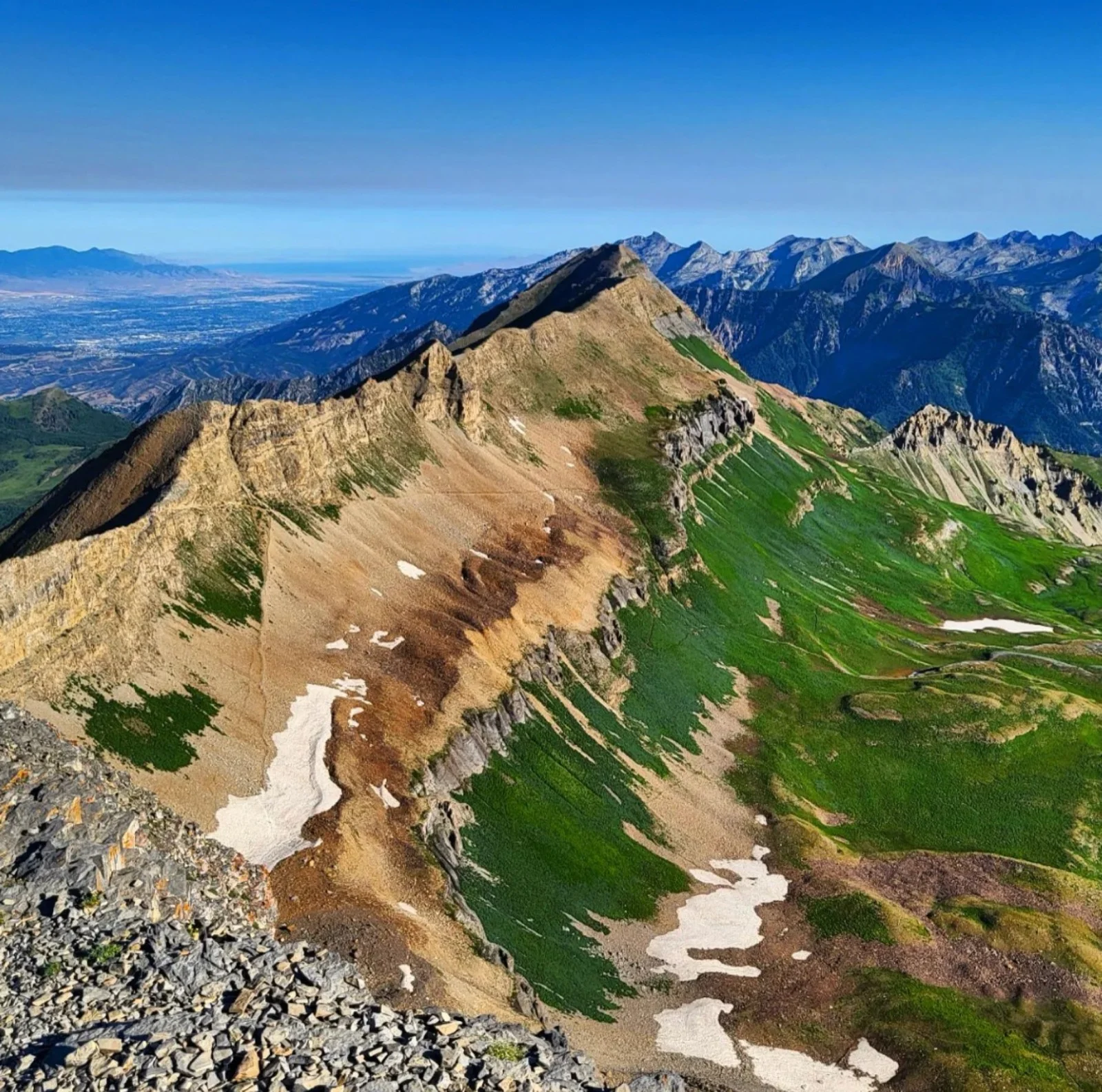
For peakbaggers collecting Wasatch 11ers, the ridge continues south from the main summit to South Timpanogos. A social trail follows the ridge with limited exposure and moderate difficulty. Mountain goats are common along this stretch. Views from South Timpanogos include Provo Canyon, Deer Creek Reservoir, and the full Timpanogos ridge behind you.
It’s technically possible to descend from South Timpanogos via the glacier into Emerald Lake to make a lollipop loop. If you hike to Emerald Lake via Aspen Grove, you can see the glissade route from below. It looks exactly as steep as it is. This is not a standard hiking route. The glacier descent requires crampons, an ice axe, and experience using both. People have been seriously injured here. Unless you have legitimate mountaineering experience, skip this and take the ridge back to the saddle the way you came.
The Loadout
This is a long day hike, not a technical climb. Gear should reflect that.
- Trekking poles: The descent is where they earn their weight. Both routes have sustained downhill sections that punish your knees over 4,000+ feet of loss.
- Microspikes: Strongly recommended in early season (July) on the Primrose Cirque via Aspen Grove. Trekking poles may be enough in lighter snow years, but don’t count on it. Optional by August. Not needed in September.
- Water filter: Non-negotiable given the mountain goat population at every water source.
- Sun protection: You’re above treeline for the upper third of both routes. The ridge walk to the summit is fully exposed.
- Wind layer: The saddle and summit ridge are exposed to constant wind. A calm day at the trailhead can be a 30-mph day on the ridge.
- 3+ liters of water: Especially if taking the Timpooneke route where the first reliable water after Scout Falls is the upper basin, 3.4 miles and 2,400 vertical feet later.
I hiked Mount Timpanogos via the Timpooneke Trail on September 10, 2014 and via the Aspen Grove Trail on July 16, 2017. Route details, distances, and conditions reflect those trips with current access information verified June 2026.