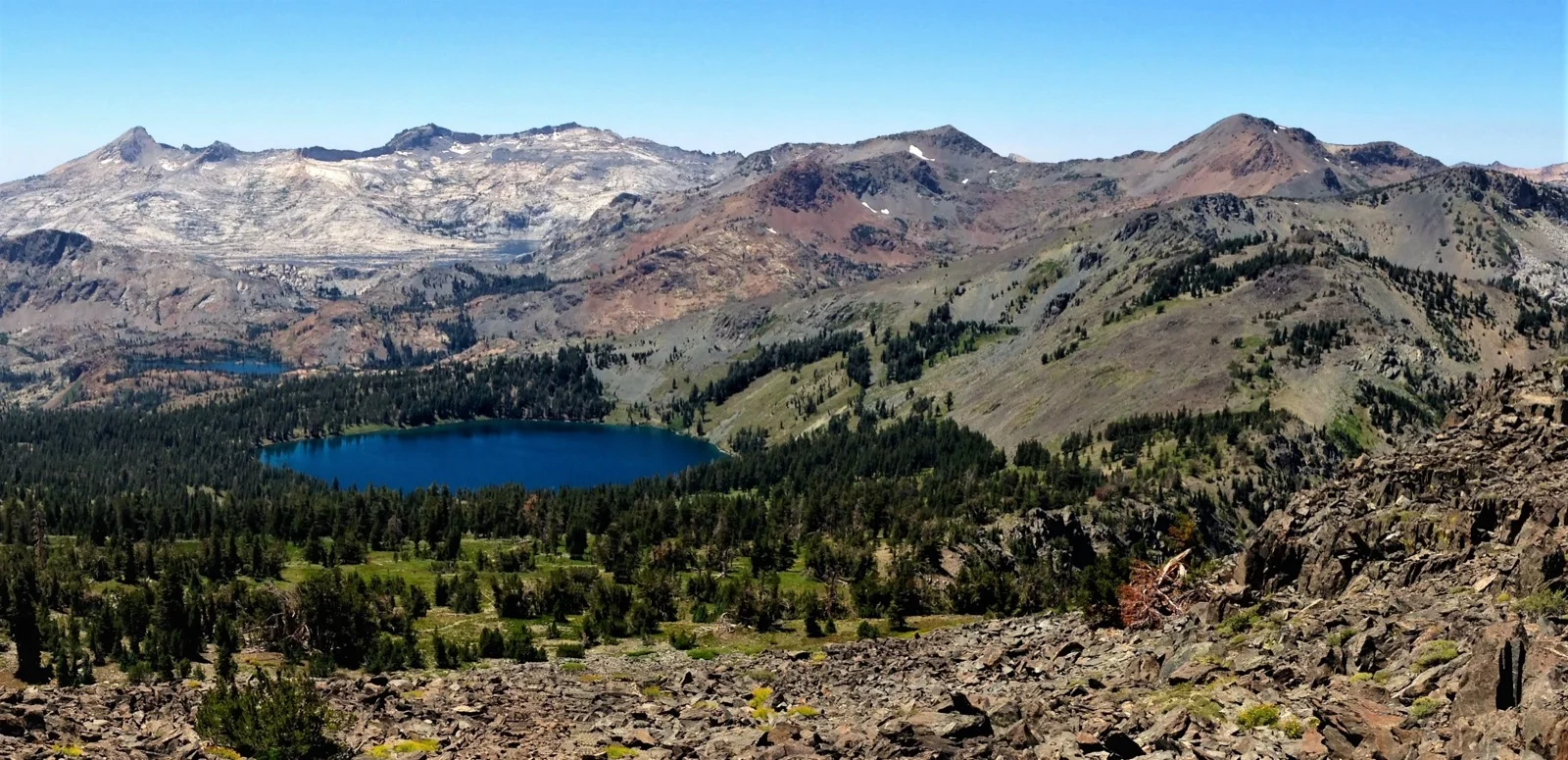
Desolation Wilderness is 63,960 acres of granite and sky wedged between South Lake Tahoe and the Crystal Range. It holds more than 130 lakes, sits within two hours of Sacramento and the Bay Area, and is one of the most heavily used wilderness areas in the United States. That combination tells you everything you need to know about the permit situation.
This is not a lottery. There is no single application window to miss. But that does not mean getting a permit here is easy. During peak season, the most popular zones sell out the moment they become bookable six months out on Recreation.gov. If you want Lake Aloha on a July weekend, you need a plan.
Key Permit Facts
| Detail | Info |
|---|---|
| Permit type | Zone-based overnight quota |
| Quota season | Friday before Memorial Day through September 30 |
| Reservation window | Up to 6 months in advance, rolling daily release |
| Permit source | Recreation.gov (permit ID: 233261) |
| Fee (1 night) | $5/person + $6/party reservation fee |
| Fee (2-14 nights) | $10/person + $6/party reservation fee |
| Walk-up availability | 30% of daily quota, day-of, in person only |
| Walk-up location | Placerville Ranger Station, Camino CA |
| Group maximum | 12 people |
| Bear canister | Required |
| Campfires | Prohibited year-round |
| Day use permit | Required, free, self-issued at trailhead |
Most competitive zones:
- Lake Aloha (Zone 33)
- Velma Lakes (Zones 16/17)
- Dicks Lake / Fontanillis Lake (Zone 23)
- Gilmore Lake / Mount Tallac (Zone 29)
How the System Works
Desolation uses a zone-based quota model. There are 45 overnight destination zones spread across the wilderness. Your permit locks you into one specific zone for your first night. After that, you can move anywhere you want inside the wilderness for the remainder of your trip.
The zone where you want to spend night one is the variable that drives everything. Zone 33 (Lake Aloha) books out months in advance on summer weekends. Zone 44 (Stony Ridge Lake) might have space available tomorrow. The zones are not equal, and the system rewards hikers who understand that.
During quota season (Friday before Memorial Day through September 30): 70% of each zone’s daily quota is reservable online through Recreation.gov, available up to 6 months in advance on a rolling daily release. The remaining 30% is held for walk-in, same-day issuance only and cannot be reserved ahead of time.
Outside quota season (October 1 through Memorial Weekend): Permits are still required year-round, but no daily quota applies. You can book same-day online or in person. This is when serious backpackers do their best trips here.
When Permits Become Available
Recreation.gov releases permits on a rolling daily basis, exactly 6 months in advance. A permit for August 1 becomes bookable on February 1. This matters because popular zones on popular dates are gone within hours of going live. Track the exact dates on our Lottery Calendar alongside the other permits you’re watching this season.
For any weekend in July or August targeting Lake Aloha, Velma Lakes, or Dicks Lake: set a calendar reminder for the exact 6-month-prior date and be at your computer at 7:00 AM Pacific. That is when permits drop.
The Walk-Up Option
Thirty percent of each zone’s daily quota is reserved for walk-in permits. These are issued in person, on the day of entry, at the Placerville Ranger Station (4260 Eight Mile Road, Camino, CA 95709). The station opens at 8:00 AM, seven days a week during quota season.
The Forest Supervisor’s Office in South Lake Tahoe (35 College Drive, South Lake Tahoe, CA 96150) also issues permits Monday through Friday, 8:00 AM to 4:30 PM.
Note: The Taylor Creek Visitor Center is not issuing permits until further notice. Do not show up there.
Walk-up strategy is straightforward but requires flexibility. Popular zones on popular dates will have walk-up slots gone within the first hour. Midweek dates and less-demanded zones are much more likely to have space. If you are trying to walk up on a Saturday morning for Lake Aloha in August, have two or three backup zones ready when you walk through the door.
One Week Out: A Second Chance
Online reservations close one week before the entry date. At that point, any unreserved quota for that date becomes available as walk-up permits. If you have been watching a date and nothing opened up, check again around the 7-day mark.
Cancellations also surface throughout this window. Recreation.gov has a notification function. Use it.
The Popular Zones (And What They Actually Are)
The 45 zones span the wilderness from north to south. Most people cluster in a handful of them. Here is what draws them there and why those zones are the hardest to get.
Zone 33 — Lake Aloha (East Side)
If someone says they got a Desolation permit, they are usually talking about this zone. Lake Aloha sits at 8,116 feet on a wide granite shelf in the southern wilderness. At peak water, it is one of the most striking alpine lakes in the Sierra. Shallow, island-dotted, and backed by the Crystal Range.
Primary access is from the Echo Lake Trailhead via the Echo Lakes/PCT corridor. From the lower Echo Lake parking area to Lake Aloha is 6.8 miles with roughly 700 feet of elevation gain. The Echo Lake water taxi (seasonal) shaves 3 miles off the approach by ferrying you across the reservoir to the upper lake for a small fee. Glen Alpine Trailhead (near Fallen Leaf Lake) is the other main approach, covering about 6 miles with more elevation.
Zone 33 has one of the largest per-night quotas in the wilderness, but that number is still overwhelmed by demand on weekends. Book at the 6-month mark or plan for a weekday trip.
One note for 2026 TRT thru-hikers: camping in Zone 33 around Lake Aloha is specifically prohibited under the TRT Thru-Hike Permit. That restriction applies only to TRT permits, not standard overnight permits.
Zones 16 and 17 — Velma Lakes
Middle Velma, Upper Velma, and Lower Velma form a chain of connected lakes in the west-central wilderness at elevations between 7,950 and 8,050 feet. Dicks Lake (Zone 23) is a short push from Upper Velma at 8,450 feet.
Primary access is from the Bayview Trailhead above Emerald Bay on Highway 89 (the trailhead sits at about 6,850 feet), or from Eagle Falls Trailhead at Emerald Bay State Park. Both routes are on the shorter end for Desolation, making this one of the most accessible overnight circuits in the wilderness. From Bayview to Middle Velma is approximately 5 miles with 1,600 feet of gain.
Zone 16 (Middle Velma area) and Zone 17 (Upper Velma) often disappear within hours of release on summer weekends. The Bayview-to-Eagle-Falls lollipop with a Velma Lakes base camp is probably the most popular overnight itinerary in the entire wilderness.
Zone 23 — Dicks Lake and Fontanillis Lake
Dicks Lake (8,450 ft) and Fontanillis Lake (8,300 ft) sit in a glacially carved bowl below Dicks Pass at 9,380 feet. This is where routes get more serious. Zone 23 has a daily quota of 16 people, with 11 reservable online. It is reachable from Bayview or from the Meeks Bay Trailhead on the north end.
The classic route through here is part of a multi-day loop: Echo Lake in, traverse south, camp Fontanillis or Dicks, cross Dicks Pass, descend to Velma Lakes, exit Eagle Falls. Four days covers it comfortably.
If Zone 23 is full, Zone 16 (Middle Velma) works as a first-night alternative before moving to Dicks or Fontanillis on night two. The zone restriction only applies to your first night.
Zone 38/39 — Lake Aloha (Additional Approach Zones)
Multiple zones cover the Lake Aloha basin from different approach vectors. Zones 38 and 39 are accessible from different trailheads and can serve as alternatives when Zone 33 is booked. If your target is Lake Aloha but Zone 33 is full, check these adjacent zones before abandoning the trip.
Zone 29 — Gilmore Lake and Mount Tallac
Gilmore Lake (8,300 ft) sits directly below Mount Tallac (9,735 ft) and is the most common base camp for the Tallac summit. The Mt. Tallac Trailhead is the standard approach: 5 miles to the summit, with Gilmore Lake at roughly mile 2.5.
This zone appeals to peak-baggers more than casual backpackers. The summit itself is the highest point in the Lake Tahoe Basin and one of the best views in the northern Sierra. If you’re deciding whether the Tallac add-on fits your trip, run the numbers through our hiking difficulty calculator.
What Most People Get Wrong
The zone system is the whole game. Most hikers fixate on “getting a Desolation permit” as if it is a single thing. It is not. You are reserving a specific first-night zone. Two hikers can both have valid permits for the same night and be camping 5 miles apart. Understand the zone map before you book.
Zone quotas vary wildly. Some zones allow as few as 2 people per night. Others allow 30 or more. If you have a group of six and you book a 4-person zone, your permit is invalid for your group. Download the zone quota PDF from the Forest Service before finalizing your zone selection.
The 6-month window is a daily roll. This is not a single lottery opening date. Every day, the date exactly 6 months away opens up. June 15 permits became bookable on December 15. July 4 opens on January 4. Set individual reminders for the dates you want; do not try to remember this by feel.
First-night zone lock, then full freedom. After your first night in your reserved zone, you can camp anywhere in the wilderness. You could book Zone 5 in the north, spend night one there, then hike south and camp near Aloha for nights two and three. The zone restriction only applies once.
Online reservations close 7 days out. If you are trying to book a last-minute trip and the online system shows nothing, it may be closed for that date. Walk-up is your only option within 7 days.
Permit Offices
Full office details, hours, and updates are maintained on the Eldorado National Forest permits page.
Placerville Ranger District 4260 Eight Mile Road, Camino, CA 95709 (530) 647-5415 Hours: 7 days/week, 8 AM to 4:30 PM (summer) Primary walk-up location.
Lake Tahoe Basin Management Unit — Forest Supervisor’s Office 35 College Drive, South Lake Tahoe, CA 96150 (530) 543-2600 Hours: Monday through Friday, 8:00 AM to 4:30 PM
Taylor Creek Visitor Center: not issuing permits until further notice.
If Your Zone Is Full
This happens constantly on summer weekends. You watched the 6-month window open, Lake Aloha or Velma was gone in hours, and now you are deciding whether to scrap the trip. Don’t. A few moves usually fix it.
Check the adjacent zones first. Lake Aloha is covered by more than one zone (33, 38, 39) approached from different trailheads. Pull up the Desolation Zones Map and check the others before giving up on the basin entirely.
Move to the west side. The Rockbound Trailhead at Wrights Lake feeds the Rubicon River drainage on the west side of the wilderness, which sees consistently lower demand than the east. It’s a convenient entry if you’re coming from the west, and it’s generally a less crowded part of the wilderness. Expect rougher trail and a longer approach in exchange for the open quota.
Target the known low-demand zones. Stony Ridge Lake and Azure Lake are routinely overlooked and rarely hit quota capacity, even at the height of summer. Stony Ridge is reached via the Meeks Bay Trail on a longer approach than most east-side destinations, which is exactly why it stays open. Use one of these as your first-night zone, then move toward your real target on night two, since the zone restriction only applies to night one.
Go midweek. Tuesday through Thursday departures have dramatically better odds than Friday or Saturday entries, even into the most popular zones.
Try Lyons Creek or Rockbound directly. If your first-choice trailhead is maxed out, hop to a neighboring one. Lyons Creek and Rockbound frequently still have quota when the east-side trailheads are gone.
None of this requires giving up on Desolation. It requires giving up on a specific zone on a specific date.
Common Trailheads
Most permits funnel through five trailheads. Echo Lake and Glen Alpine handle the Lake Aloha traffic. Bayview and Eagle Falls handle the Velma Lakes and Dicks/Fontanillis traffic. Loon Lake is the main west-side entry for hikers working the quieter Rubicon side of the wilderness.
If you are checking availability across multiple zones, these five are the ones to watch first.
Note: Pyramid Creek, Loon Lake, Rockbound, and Twin Lakes trailheads charge a $10/day parking fee. Overnight permit holders have that fee waived. A parking pass prints as part of your permit confirmation.
Regulations That Matter
Bear canister: required. Hard-sided only. The fine for non-compliance is up to $5,000. Bring the canister.
Campfires: prohibited everywhere in Desolation Wilderness, year-round. No exceptions. Use your stove. As of March 20, 2026, a stove use permit is also required for day users carrying a camp stove into the wilderness. For overnight permit holders, this is already covered by your permit.
Day use permits: required, free, self-issued. If you are day hiking into Desolation from any trailhead during summer, you need a permit. Pick one up at the trailhead kiosk.
Maximum group size: 12. This is also a per-zone-per-night cap. Some zones have smaller quotas than 12.
Signed permit carried at all times. A digital or printed reservation confirmation is not a valid permit. You must print and sign the actual permit, available within 7 days of your entry date through Recreation.gov.
TRT Thru-Hikers (2026 Update)
A new permit category launched March 20, 2026, specifically for Tahoe Rim Trail thru-hikers. If you are completing the full TRT in a single continuous journey, you need the TRT Thru-Hike Permit rather than a standard overnight permit for the Desolation section. Details and full TRT planning resources are maintained by the Tahoe Rim Trail Association. Zone 46 is designated for this use only. Ten spaces per night. Maximum 2 nights in Desolation while on the TRT corridor. Camping must be within 300 feet of the PCT/TRT. Lake Aloha area (Zone 33) is off-limits under this permit.
Book through Recreation.gov; these permits became available March 20, 2026.
Off-Season Is Underrated
Desolation outside quota season (October through Memorial Weekend) is a different place. Snow arrives early and lingers late, some trailheads close, and conditions require winter preparedness. But permits are same-day, trails are empty, and the granite lake basins look different under a dusting of snow.
If your schedule allows any flexibility into early October before snowfall or late May after the trailheads open, the experience-to-crowd ratio shifts dramatically. The wilderness does not change. The people do.
Same logic applies to other quota-managed permits. Our South Sister permit guide walks through a similar zone-and-timing problem on a shorter season.
Gear Required
Bear canister: required. The BV500 (686 cubic inches) fits 5-6 days of food for most backpackers. Lighter option is the Bearikade Weekender (650 cubic inches, 1.98 lbs) if you are counting ounces.
Microspikes: not required but strongly recommended before mid-July, when snow covers passes and approach trails. Check current conditions through the Placerville Ranger Station before your trip.
No campfires means your kitchen is your stove. Bring enough fuel.
Hero photo: Desolation Wilderness from Mount Tallac, by jcookfisher via Flickr, licensed under CC BY 2.0.
Permit information verified against Recreation.gov and Eldorado National Forest agency sources, June 2026. Fees, quotas, and regulations are subject to change. Verify current conditions at fs.usda.gov/r05/eldorado/permits/desolation-wilderness-permits before your trip.